![](/images/other/stat-length.png)
![Excursión Senderismo La Loupe - [Itinéraire] La Trinité des Bois - Photo](https://media.geolcdn.com/t/1900/400/ext.pjpeg?maxdim=2&url=https%3A%2F%2Fstatic1.geolcdn.com%2Fsiteimages%2Fupload%2Ffiles%2F1553511878bg_sport_marche.png)
[Itinéraire] La Trinité des Bois
ODDAD78
Usuario
![Longitud](/images/other/stat-length.png)
![Altitud máxima](https://static1.geolcdn.com/siteimages/upload/files/1508320355ic_sort_altitude_max_24dp.png)
![Desnivel positivo](https://static1.geolcdn.com/siteimages/upload/files/1508320355ic_sort_den_pos_24dp.png)
![Km-Effort](/images/other/stat-length.png)
![Altitud mínima](https://static1.geolcdn.com/siteimages/upload/files/1508320355ic_sort_altitude_min_24dp.png)
![Desnivel negativo](https://static1.geolcdn.com/siteimages/upload/files/1508320355ic_sort_den_neg_24dp.png)
![Boucle](https://static1.geolcdn.com/siteimages/upload/files/16400158638029165_repeat_loop_refresh_sync_direction_icon.png)
![Senderismo](https://static1.geolcdn.com/sitytour/trail-icons/101.png)
3h25
Dificultad : Difícil
![Escanee este código QR para abrir la excursión en la aplicación SityTrail](https://capi.geolives.com/qq0zvz2zws4bq2lad0pu/sitytour/trails/3785973/qr.png?size=200)
Aplicación GPS de excursión GRATIS
A propósito
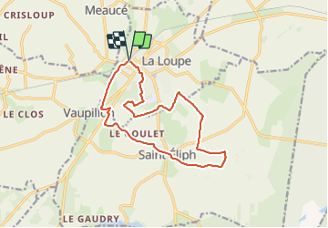
Ruta Senderismo de 13,7 km a descubrir en Centro, Eure-y-Loir, La Loupe. Esta ruta ha sido propuesta por ODDAD78.
Descripción
Départ : La Loupe, gare
Arrivée : La Loupe, gare Balisage : GR® GRP® PR Communes : 1. La Loupe
2. Saint-Eliph
1. Dos à la gare, prendre à droite, rue d'Alençon. A 200m, tourner à droite dans la rue du Gros Chêne. Puis, avant le pont, prendre à gauche, dans la rue du chemin vert, sur 1.3km.
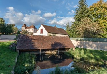
2. A l'extrémité de cette voie, traverser la route et prendre le chemin en face sur 50m. Laisser le chemin de droite et monter jusqu'à la route de Nogent-le-Rotrou. Traverser prudemment et suivre l'accotement . A 100m, prendre la 1ère route à gauche. Suivre cette rue pendant 200m et tourner à droite, puis à gauche, sur la route de Vaufermé. Après 80m prendre le chemin qui va tout droit. Suivre ce chemin jusqu'au lavoir de St Eliph.
3. En sortant du chemin prendre sur gauche la rue de l'école jusqu'à la Mairie. Au bout de la rue, tourner à gauche puis prendre la 1ère à droite : la D349.4 pendant 1km (Aux Croisettes, jonction de la liaison avec le GR 35, venant de Montireau par la droite et allant en face vers la forêt de Montécôt).
4. Au transformateur (après la Cocherie), tourner à gauche en direction de la Grande Sergenterie (on quitte son GR et son balisage blanc et rouge). Traverser la Grande Sergenterie, faire 100m et prendre le chemin sur la gauche. A son extrémité, tourner à droite et traverser la D349. Prendre la route en face et la suivre pendant 800m.
5. Tourner à gauche en direction de la Margotière, puis suivre le chemin jusqu'à l'entrée de la Glonnerie. Prendre le chemin à gauche et le suivre jusqu'à l'Evarderie. Puis continuer jusqu'à rejoindre la D 941. Prendre à gauche, puis la 1ère route à droite direction "Le Goulet" pendant 700m.
6. Laisser "le Goulet" sur gauche et prendre à droite le chemin qui descend pendant 400m. 100m après la lisière du bois, tourner à droite pour emprunter le sentier qui y pénètre. Suivre ce sentier pendant 250m. A l'intersection, laisser le sentier venant de droite et se diriger vers la lisière que l'on atteint près de l'angle d'un champs. Le sentier s'incurve ensuite vers la gauche et longe bientôt les terrains de sport.
7. Traverser une 1ère allée, en couper ensuite une autre plus large près de l'entrée du stade. Passer près du gros chêne au pied du château d'eau. Continuer toujours dans la même direction, vers le gymnase. Peu avant, prendre à droite, puis à gauche, pour atteindre une allée goudronnée qui contourne le château par la droite et conduit à la place Vauban. Traverser cette place et prendre en face la rue du château. Traverser la place de l'hôtel de ville et descendre pour rejoindre la gare.
(Pas à pas : Rando-Perche)
Localización
Comentarios
Excursiones cerca
![Excursión Senderismo La Loupe - Traversées Percheronnes La Loupe - La Madeleine-Bouvet 14,1km PROJET - Photo](https://media.geolcdn.com/t/375/260/da8e7063-6553-44fc-b42f-4584a54085e6.jpg&format=jpg&maxdim=2)
![Senderismo Senderismo](https://static1.geolcdn.com/sitytour/trail-icons/101.png)
Senderismo
![](/images/other/stat-length.png)
![](https://static1.geolcdn.com/siteimages/upload/files/16400158638029165_repeat_loop_refresh_sync_direction_icon.png)
![Excursión Senderismo La Loupe - Traversées Percheronnes La Loupe - Senonches 13,4km PROJET - Photo](https://media.geolcdn.com/t/375/260/266ddd29-9201-4435-8335-f34182e16094.jpg&format=jpg&maxdim=2)
![Senderismo Senderismo](https://static1.geolcdn.com/sitytour/trail-icons/101.png)
Senderismo
![](/images/other/stat-length.png)
![](https://static1.geolcdn.com/siteimages/upload/files/16400158638029165_repeat_loop_refresh_sync_direction_icon.png)
![Excursión Senderismo La Loupe - La Loupe - Saint-Victor-de-Buthon 10 km - Photo](https://media.geolcdn.com/t/375/260/e40de329-9072-4156-a02a-69d09a277383.jpg&format=jpg&maxdim=2)
![Senderismo Senderismo](https://static1.geolcdn.com/sitytour/trail-icons/101.png)
Senderismo
![](/images/other/stat-length.png)
![](https://static1.geolcdn.com/siteimages/upload/files/16400158638029165_repeat_loop_refresh_sync_direction_icon.png)
![Excursión Bici de montaña Fontaine-Simon - Forêt et vallée de l'Eure - Fontaine-Simon - Photo](https://media.geolcdn.com/t/375/260/ext.jpg?maxdim=2&url=https%3A%2F%2Fservices.sitytrail.com%2FGeolivesWS%2FDownloadMedia.ashx%3FTrailID%3D172493%26Media%3D13852_5.jpg)
![Bici de montaña Bici de montaña](https://static1.geolcdn.com/sitytour/trail-icons/202.png)
Bici de montaña
![](/images/other/stat-length.png)
![](https://static1.geolcdn.com/siteimages/upload/files/16400158638029165_repeat_loop_refresh_sync_direction_icon.png)
![Excursión Senderismo Fontaine-Simon - Forêt et vallée de l'Eure - Fontaine-Simon - Photo](https://media.geolcdn.com/t/375/260/ext.jpg?maxdim=2&url=https%3A%2F%2Fservices.sitytrail.com%2FGeolivesWS%2FDownloadMedia.ashx%3FTrailID%3D172492%26Media%3D13852_5.jpg)
![Senderismo Senderismo](https://static1.geolcdn.com/sitytour/trail-icons/101.png)
Senderismo
![](/images/other/stat-length.png)
![](https://static1.geolcdn.com/siteimages/upload/files/16400158638029165_repeat_loop_refresh_sync_direction_icon.png)
![Excursión Senderismo Fontaine-Simon - Fontaine-Simon, Forêt de Senonche, Manou, La Ferrière - Photo](https://media.geolcdn.com/t/375/260/ext.jpg?maxdim=2&url=https%3A%2F%2Fstatic1.geolcdn.com%2Fsiteimages%2Fupload%2Ffiles%2F1553511878bg_sport_marche.png)
![Senderismo Senderismo](https://static1.geolcdn.com/sitytour/trail-icons/101.png)
Senderismo
![](/images/other/stat-length.png)
![](https://static1.geolcdn.com/siteimages/upload/files/16400158638029165_repeat_loop_refresh_sync_direction_icon.png)
![Excursión Senderismo Belhomert-Guéhouville - Belhomert 8,0km - Photo](https://media.geolcdn.com/t/375/260/ext.jpg?maxdim=2&url=https%3A%2F%2Fstatic1.geolcdn.com%2Fsiteimages%2Fupload%2Ffiles%2F1553511878bg_sport_marche.png)
![Senderismo Senderismo](https://static1.geolcdn.com/sitytour/trail-icons/101.png)
Senderismo
![](/images/other/stat-length.png)
![](https://static1.geolcdn.com/siteimages/upload/files/16400158638029165_repeat_loop_refresh_sync_direction_icon.png)
![Excursión Senderismo Fontaine-Simon - Fontaine-Simon 7.7 Km - Photo](https://media.geolcdn.com/t/375/260/ext.jpg?maxdim=2&url=https%3A%2F%2Fstatic1.geolcdn.com%2Fsiteimages%2Fupload%2Ffiles%2F1553511878bg_sport_marche.png)
![Senderismo Senderismo](https://static1.geolcdn.com/sitytour/trail-icons/101.png)
Senderismo
![](/images/other/stat-length.png)
![](https://static1.geolcdn.com/siteimages/upload/files/16400158638029165_repeat_loop_refresh_sync_direction_icon.png)
![Excursión Senderismo Fontaine-Simon - Senonche Forêt domaniale 17.3 Km - Photo](https://media.geolcdn.com/t/375/260/ext.jpg?maxdim=2&url=https%3A%2F%2Fstatic1.geolcdn.com%2Fsiteimages%2Fupload%2Ffiles%2F1553511878bg_sport_marche.png)
![Senderismo Senderismo](https://static1.geolcdn.com/sitytour/trail-icons/101.png)
Senderismo
![](/images/other/stat-length.png)
![](https://static1.geolcdn.com/siteimages/upload/files/16400158638029165_repeat_loop_refresh_sync_direction_icon.png)